Volcano-tectonic activity on the Reykjanes Peninsula since 2019: Overview and associated hazards

Michelle Parks1, Freysteinn Sigmundsson2, Sara Barsotti1, Halldór Geirsson2, Kristín S. Vogfjörð1, Benedikt Ófeigsson1, Páll Einarsson2
1 Icelandic Meteorological Office, Reykjavik, Iceland.
2 Nordic Volcanological Center, Institute and Faculty of Earth Sciences, University of Iceland, Reykjavik, Iceland.
Overview and background
Volcano-tectonic reactivation of the Reykjanes Peninsula commenced in December 2019, and accounts for, so far, four dike intrusions and three eruptions in the Fagradalsfjall area, and an additional four dike intrusions and three eruptions in the Svartsengi volcanic system, in the area at and near the Sundhnúkur crater row, extending into Grindavík (see Figure 1).
When the unrest started in 2019, a series of earthquakes were detected in the Fagradalsfjall region at depths between 3-7 km. The timing of the reactivation of volcanic activity on the Reykjanes Peninsula was not unexpected, considering knowledge about the previous eruptive period, with the average interval between eruptive activity being about 800-1000 years. The preceding period of eruptive activity, Reykjaneseldar, lasted from 950 to1240. The first clear sign of new magma migration beneath the peninsula was detected on 21 January 2020 – with a strong increase in seismicity and crustal deformation marking the first uplift period in the Svartsengi area, indicative of pressure increase in the crust and interpreted as magma accumulation. The first diking and eruptive activity in the ongoing activity period was, however, in the Fagradalsfjall area. From February 2021 until August 2023, 4 dike intrusions and 3 eruptions occurred there (Figure 1). Seismicity and geodetic data has been crucial for evaluating the nature of the hazards in the areas influenced.
At Fagradalsfjall, the first dike intrusion (the largest to date in this area) took place from 24 February until 19 March 2021, when an eruption began. Ground deformation and seismicity were studied and reported by Sigmundsson et al. (2022). The inferred initial magma inflow rate into the dike was 30-35 m3/s which reduced to <10 m3/s prior to the eruption onset. Our measurements and analyses have shown a strong correlation between inferred inflow rate to the dike immediately before eruption onset and the initial lava extrusion rate, which is very important for determining the risk related to lava flows.
At Svartsengi, the initial period of uplift in January 2020, was followed by 4 additional uplift periods (two of which occurred in 2020 between March – April and May – July, one in May-June 2022 and an additional period from 27 October to 10 November 2023). Magma accumulation in the last period caused sufficient pressure increase to trigger a major dike intrusion on 10 November 2023 under the Sundhnúkur crater row and the town of Grindavík (Figure 2; Sigmundsson et al., 2024).
Figure 1. Western part of the Reykjanes Peninsula in SW-Iceland showing the Svartsengi, Reykjanes (R) and Fagradalsfjall (F) volcanic systems, fractures, fissure swarms, plate boundary central axis, the 2021-2023 Fagradalsfjall lavas, and lava fields from the previous eruptive period ending in the 13th century CE. Inset show Iceland with fissure swarms (yellow areas) central volcanoes (dashed ovals) and far-field spreading direction and the area of the main map. Reproduced with permission from Sigmundsson et al. (2024).

The first dike intrusion at Fagradalsfjall triggered over 20 thousand earthquakes across the whole Reykjanes Peninsula, including over 60 events of magnitudes greater than MW4, and 6 events of magnitudes greater than MW5. Such large earthquakes near inhabited areas cause a significant seismic risk to people and infrastructure, as well as causing rockfall from steep slopes. Most of these larger events were in close proximity to the dike. The later dike intrusions at Fagradalsfjall generated less seismicity and thus represented a lower seismic hazard.
The first dike intrusion in the Grindavík/Svartsengi area also triggered over 20 thousand earthquakes across the Peninsula, including over 40 events of magnitudes greater than MW4, and 2 events of magnitudes greater than MW5. As before, most of the seismicity was in the vicinity of the dike. This time, however, great seismic risk to both people and infrastructure was created by the extreme intensity of the seismicity, including over 25 MW4 events and one MW5.2 event occurring within only 8 hours, in close proximity of and some even underneath the town of Grindavík and important infrastructures like the Svartsengi Power Plant and Blue Lagoon. The three subsequent dike intrusions in December 2023, January and February 2024 generated much less seismicity, including only one MW4 event and thus constituted a lower seismic hazard. The shaking from this smaller scale seismicity, however, may have caused movements on the many surface faults and fractures created or activated within the wider Grindavík area by the shallow dike intrusions.
Differences between the magmatic systems beneath Fagradalsfjall and the Sundhnúkur crater row
The main difference between the dike intrusions and eruptions thus far at Fagradalsfjall and Sundhnúksgígar-Gríndavík is how the magma accumulates prior to events and how it is migrating within the crust.
At Fagradalsfjall, the magma is being transferred from around 10-15 km depth (Halldórsson et al., 2022), which is feeding lateral dike intrusions in the upper crust between depths of ~1 to 6 km. When the main dike has finished propagating laterally, and if the pressure is still building due to continued magma inflow into the dike, then additional dike opening near the surface can occur, and magma starts its final ascent towards the surface. When this occurs, we have observed a decline in both the deformation and the seismicity. We believe this occurs when the dike can no longer propagate laterally as it has released the tectonic forces previously built-up in the crust by the plate spreading, but if magma is still flowing into the dike, the pressure continues to build and then the magma begins to migrate upward. The upper 1 km of the crust is weaker than below, thus magma migration towards the surface does not necessarily produce significant seismicity. This is why it was possible to forecast the onset of eruptions at Fagradalsfjall during 2022 and 2023 using measurements of crustal deformation and seismicity, modelled evolution and top depth of dike intrusions inferred from these data sets and identification of a decline in seismicity as the unrest evolved (Parks et al., 2023).
Figure 2. Crustal deformation in relation to the 10 November 2023 dike major dike intrusion as seen in an interferogram based on data from the Italian COSMO-SkyMed satellite. Each color fringe corresponds to 1.5 cm of change in the satellite’s line-of-sight.

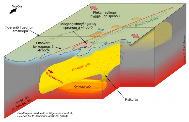
In the Svartsengi area, the crustal magma domain feeding the dike intrusions resides at a much shallower level compared to Fagradalsfjall, at about 4-5 km depth according to interpretation of geodetic measurements. Magma is being injected rapidly into dike intrusions when the critical pressure is reached and the boundary of the magma domain fails. Geodetic data and modelling indicates that the five inflation episodes in this area that occurred between 21 January 2020 and 10 November 2023 were in fact injections of magma into an extensive pre-existing magma domain (Figure 3). It is referred to as the Svartsengi magma domain, as it is in the center of the Svartsengi volcanic system. However, it extends over a very broad region (spanning close to Eldvörp in the west to the Sundhúkur crater row in the east – and lies beneath the Blue Lagoon and Svartsengi power plant). Crustal magmatic activity in both the Fagradalsfjall and Svartsengi areas, are in turn fed by magma flow from the mantle or the crust-mantle boundary (Halldórsson et al., 2022; Sigmundsson et al., 2024).
Data interpretation and hazard assessment
During the 10 November dike injection, the estimated peak magma inflow rate to the dike was over 7000 m3/s (Sigmundsson et al., 2024), two orders of magnitude greater than the inferred maximum inflow rates into the dikes at Fagradalsfjall. This information, combined with confirmation from geodetic measurements and seismic data that the dike had indeed been intruded beneath Grindavík, necessitated the urgent evacuation of the town inhabitants on 10 November, 2023. On 18 December, the Svartsengi magma domain once again reached critical pressure and this time triggered an additional rapid dike opening extending to the surface. An eruption began. Its onset was also rapid – commencing only 1.5 hours following a preceding seismic swarm. The inferred peak magma inflow rate into the dike at this time was ~800 m3/s. Similar events occurred in January and February 2024. The January 2024 dike also propagated under Grindavík. This time it took a new path east of the 10 November dike and propagated beneath the center of the town. On 8 February, the time from the earliest warning of the short-term precursor (seismicity) which triggered the alert to the Civil Protection until the eruption broke out was only 35 minutes. If more dike propagations occur in the near-future then it is considered most probable that pre-existing magma pathways will guide the dikes into the Sundhnúkar-Grindavík region. However, formation of dikes in other parts of the volcanic system cannot be excluded.
The reason why the current activity is more hazardous than the activity in the vicinity of the Fagradaslfjall volcanic system results from a combination of close proximity to the town of Grindavík, the Blue Lagoon, Svartsengi power plant and critical infrastructure, in addition to the much higher magma inflow and lava extrusion rates. This is also because the inferred outflow path from the Svartsengi magma domain has a relatively large cross-sectional area, facilitating rapid magma flow to shallow levels in the crust and to the surface. A schematic outlining the sources feeding the most recent activity and the processes involved is displayed in Figure 3.
It was possible to give a long-term warning about timing of the events in January and February 2024 by modelling the re-inflation signal and assuming that the volume lost from the Svartsengi magma domain during the prior event needs to be replenished before the next dike intrusion/eruption will occur. However, i) there is still uncertainty associated with these warnings and ii) the assumption may not hold as the activity continues, due to both changes within the magma plumbing system and stress changes within the surrounding crust.
Activity during the past 3 years has switched between the Svartsengi and Fagradalsfjall volcanic systems. During the previous phase of volcanic activity on the Peninsula, which ended some 800 years ago, activity also switched between neighbouring volcanic systems. Although the volcanic eruptions in recent years have been relatively small to date, historic activity suggests that future eruptions have the potential to output larger volumes of lava.
The hazards within the Svartsengi volcanic system include (but are not limited to):
- Eruptive fissure openings
- Lava fountaining
- Lava flows
- Tephra fall
- Gas pollution
- Earthquakes of magnitudes up to and greater than MW5
- Development/opening of fractures
- Slumping/development of sink holes
- Rockfalls
- Increased risk of sea flooding due to lowered elevation of Grindavík
The Icelandic Meteorological Office, in collaboration with various research institutions in Iceland, is closely monitoring magma movements and volcanic activity in the area. However, there is a likelihood that a short-term warning will be issued less than 30 minutes prior to the onset of a future eruption if the eruption begins in the area between Sýlingarfell and Stóra-Skógfell, in a similar location to the 8 February eruption. This is because of possible changes within the Svartsengi magma domain, magma pathways and the surrounding stress field. Thus far, when the Svartsengi magma domain failed, magma was rapidly injected into a connecting conduit which then fed the dike intrusions and eruptions. Previously built-up tectonic stresses in the crust facilitates dike propagations, but as dikes are intruded this stress is released. A dike propagation phase prolongs the time between failure of the magma domain and eruption onset. If this phase is reduced or no longer required, it is possible for future eruptions to begin more rapidly. If a dike propagates outside the region between Sýlingarfell and Stóra-Skógfell – either to the northeast of Stóra-Skógfell or to the southwest towards or underneath Grindavík, a longer warning time is expected, likely between 1-5 hours.
While the connecting conduit from the Svartsengi magma domain and location of prior dike intrusions in the area remains an easy pathway, these will guide magma into a similar region as in the past eruptions, however, other scenarios cannot be completely excluded.
References
Halldórsson, S. A., Marshall, E. W., Caracciolo, A., Matthews, S., Bali, E., Rasmussen, M. B., ... & Stefánsson, A. (2022). Rapid shifting of a deep magmatic source at Fagradalsfjall volcano, Iceland. Nature, 609(7927), 529-534.
Parks, M., Sigmundsson, F., Drouin, V., Hjartardóttir, Á. R., Geirsson, H., Hooper, A., ... & Fridriksdóttir, H. M. (2023). Deformation, seismicity, and monitoring response preceding and during the 2022 Fagradalsfjall eruption, Iceland. Bulletin of Volcanology, 85(10), 60.
Sigmundsson, F., Parks, M., Hooper, A., Geirsson, H., Vogfjörd, K. S., Drouin, V., ... & Ágústsdóttir, T. (2022). Deformation and seismicity decline before the 2021 Fagradalsfjall eruption. Nature, 609(7927), 523-528.
Sigmundsson, F., Parks, M., Geirsson, H., Hooper, A., Drouin, V., Vogfjörd, K. S., ... & Barsotti, S. (2024). Fracturing and tectonic stress drives ultrarapid magma flow into dikes. Science, eadn2838.